Sandakphu
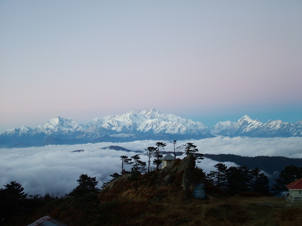
Sandakphu or Sandakfu or Sandakpur (3636 m; 11,941 ft) is the highest peak in the district of Ilam, Nepal and West Bengal, India. It is the highest point of the Singalila Ridge in Darjeeling district on the West Bengal-Nepal border. The peak is located at the edge of the Singalila National Park and has a small village on the summit with a few hostels. Four of the five highest peaks in the world, Everest, Kangchenjunga, Lhotse and Makalu can be seen from its summit. It also affords a pristine view of the entire Kangchenjunga Range.
Sandakphu Trek
Introduction
Sandakphu is not only the most popular trek in West Bengal but it is also one of the best treks in Eastern India. At an altitude of 3636 meters or 11930 feet, this is the highest point in Bengal.Sandakphu epitomises the wild elemental grandeur of the snows. Nature here is at her pristine best, and the vista at the top is worth all the hardship endured on the way. Aptly called the Paradise of Trekkers, the peak is a vantage point from where one can see four of the world's five highest peaks - Everest, Kanchenjunga, Makalu and Lhotse - in a continuous snow-clad arc.
The trek is a relatively easy and can be enjoyed by young or older people with reasonably good fitness. Sandakphu is also accessible by Jeep, though the road condition is quite poor and the Jeeps are very old vintages.
The trek to Sandakphu passes through the Singalila National Park which is home for the unique Red Panda. The trek follows a mountain ridge which is also the international boarder between India and Nepal.
The name Sandakphu means the 'Height of the Poison Plant', a direct reference to the profusion of the poisonous aconite plants that grow near the peak. The loftiest peak of the Singalila Range, it is the culminating point of many trekking routes in the Darjeeling - Sikkim region.
Maneybhanjang to Sandakphu Trek Distance
Maneybhanjan, at an altitude of 2134 mtr, is the gateway to the Sandakphu region, it is situated about 25 kms from Darjeeling. After necessary entries in the forest check post and last minute shopping and meals, the trek begins. You may also opt for overnight stay at Maneybhanjang and start the trek early next day. The total distance from Maneybhanjang to Sandakphu is about 31 kms. The distance may be covered in two to three days. On your onward trek from Sandakphu you can continue towards Phalut or simply decent towards Rimbik, there are several options for this and the trek down may be undertaken in 1 to 4 days.
Description of the trek / Places on the Way
You can start your day either at Darjeeling, Maneybhanjang or at Chitrey. If you stay overnight at Darjeeling, you should start early and drive to Maneybhanjang, which is about an hours drive.
Apart from being the base for treks to Sandakphu, Maneybhanjang is also famous for its Land Rovers. These rugged beauties rule the mountain trail in this area. Some of the vehicles are more than 70 or 80 years old. Maneybhanjang is also a border town. While coming from Darjeeling, the houses on the left of the road belong to Nepal and the right side being India. Most trekkers start their trek at Maneybhanjang. There are a few trekker’s huts and small hotels where one can put up for a night.
Chitrey – If you want to avoid the steep climb immediately on start of the trek, you may drive a couple of kms further from Maneybhanjang and reach Chitrey. The route passes quite steeply uphill through lush greenery of pine, fir, birch forests and bamboo glades. It takes about an hour and half to reach Chitrey (2530 m). As for the entire trek route, you will be passing through the Indo-Nepal boarder here. The road being on the Indian side and the small human settlement on the Nepal side. There is a homestay / trekkers hut here as well. So one may even decide to reach Chitrey for overnight stay and start the trek from here. There is also a large monastery at Chitrey which is worth a visit.
Lamey Dhura – About 3 kms ahead of Chitrey is the small settlement of Lamey Dhura. Between Chitrey and Lamedhura you will be trekking through a ridge. Here there are only a couple of cottages selling hot tea and other knickknacks for the trekkers.
Meghma Another 3 kms from Lamey Dhura is the location of Meghama. This is a relatively larger settlement. The trail bifurcates at Meghma. The right uphill route leads to the trekkers hut at Tonglu (3070m) in India. The trail in the left passes through Nepal. The roads meet again at Tumling (in Nepal). There is a large SSB (Security Agency) camp at Meghma, there is also a monastery and a primary school.
Tonglu – If you have taken the road on your right at Meghma, Tonglu would be about 2 kms. Perched on top of a hill, Tonglu will mesmerize you with its view of the Kanchanjunga reflection on Tonglu Lake. Some trekkers to Sandakphu avoid the main trek route and start at Dhotrey which is about 5 kms from Tonglu. Although this is a less popular route, it leads to a saving of about 5 kms.
Tumling – 2 kms ahead of Meghma through the left route is the location of this small Nepal village. Tonglu is famous for the view of the snow-capped peaks of the Singalila and the Kanchenjunga range. Tumling on the other hand is a salubrious night halt with assorted lodges dotting its sedate green environs. The lights of the towns of Darjeeling, Kurseong, Pasupati (Nepal), Siliguri and other settlements can be viewed on a clear night.
The trek from Tonglu or Tumling towards Sandakphu is rewarded with a wide variety of flora, fauna and avifauna as you enter the Singalila National Park. About a km ahead of Tumling you will find the forest check post for Singalila National Park. Here you have to get the pass for entry into the National Park. From the check post there are three different routes taking you to Gairibans. There is a hilltop ahead which you can avoid if you take the left route through Joubari (Nepal) or the right route through India. Alternatively you may decide to walk over the hill and come down to Gairibans on the other side.
Joubari in Nepal is a settlement with a police check post, do not continue on the road from Joubari onwards as it enters deeper into Nepal, instead take a right turn and cross the village to enter back into India. There are several small shops at Joubari including some offering overnight basic accommodation. Tumling to Joubari is about 5 kms and from Joubari to Gairibans is about 3 kms. The area is the house of wide varieties of Rhododendron and the playing ground of Red Pandas. Goiribans (2621 m) is rather down the hills at a much lower altitude. There are a couple of trekker huts here and those planning to reach Sandakphu in 2 days often stay overnight here. The trek from Gairibans climbs steep uphill for a couple of kms till you reach the top of the hill. Continue anoth km or so to reach Kaiyakatta.
Kaiyakatta is another small village where you can take a break a sip a cup of tea. In Nepali language Kaiya refers to the non-Nepalese business communities and Katta refers to cutting or killing. So Kaiyakatta refers to some gory event of yore which no one seems to remember now. From here the next village is Kalepokhri.
Kalepokhri (3 km from Kaiyakatta) is a village in Nepal situated at an altitude of 3108 m. Being relatively high in altitude and on top of a ridge, there is heavy wind blowing through the village all times of the day. There are a couple of trekkers’ huts here as well. The trek from Tumling to Kalepokhri takes about 5 hours. At Kalepokhri there is a small crystal lake surrounded by pine trees and prayer flags. The dark color of the water in the lake leads to the name of Kalepokhri (kale = Black, Pokhri = Lake). From Kalepokhri, Sandakphu is just about 8 kms ahead.
Bikeybhanjan is the last hamlet before you reach your final destination. Bikeybhanjan is just 2 kms from Kalepokhri. Even though you have covered most of the distance and Sandakphu is visible and just 5 kms ahead, this is the steepest and the most difficult stretch of your trek. After a tough trek for about 3 hours, you will reach Sandakphu (3636m), the highest point in West Bengal. A day's halt here allows trekkers to view the surroundings.
From Sandakphu there are several trekking options available to the tourists. You can go down to Rimbik directly by a shortcut route through dense forests. You can move on to Phalut (3600m) from where you can further visit to Molley, Rammam, Gorkey or Rimbik. Rimbik is the road head on the other side of the trek. From here you will be taken to your next destination. The main trek route through the Singalila ridge goes on to reach Phalut through Sabarkum.
Sabarkum is a village on the Indian side of the boarder and one of the highest points in Bengal. It is about 15 kms from Sandakphu towards Phalut. Most people prefer to continue the trek till Phalut for overnight stay. Sabarkum is a destination on its own right with magnificent views of the Kanchenjunga range. There is a train from here that goes to Srikhola / Gorkey. On your way back from Phalut, this might be your best route.
Phalut further 7 kms from Sarbarkum is the second highest point in Bengal (3600 m). For most trekkers this is the last destination before starting back. Some adventure lovers may also continue towards Sikkim through Singali pass and Kalijhar. This route is little explored not suggested for general trekkers.
Gorkey on the other hand is visited by a majority of trekkers on their way down. It is about 15 kms from Phalut. From Gorkey one can trek to Srikhola about 12 kms ahead.
Gurdum if your trek does not go beyond Sandakphu, you may decide to trek down through Gurdum. There is a direct downhill trek to Gurdum through dense forests. The distance is about 12 kms and takes about 4 / 5 hours. Gurdum is a village with a couple of trekkers huts.
Srikhola – Further couple of hours trek from Gurdum will take you to Srikhola. This is where the vehicular roads end. On the way between Gurdum and Srikhola is another small village of Timbure which has some homestay accommodations. From Srikhola you can drive out through Rimbik and
Maneybhanjan and back to Darjeeling or Siliguri.
Tour Ideas
naturebeyond organises treks to Sandakphu on a regular basis. Our treks are customised as per guest requirements. The trek is ideally organised for a group of 6-15 although smaller or larger groups can also be managed.
Duration : 6 - 11 days.
Things to carry : Warm clothes, a good pair of sneakers, a rucksack and raincoat is all that you need to carry.
Food : The staple diet is rice and chapatti. Food is sufficient and decent. For groups requiring different foods, such as international travellers, cook and food is carried with the group.
