WEST BENGAL
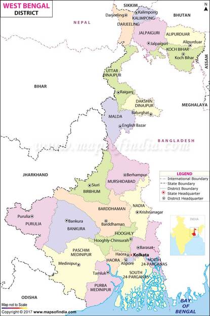
West Bengal is an Indian state, located in Eastern India on the Bay of Bengal. It is India's fourth-most populous state, with over 91 million inhabitants (as of 2011). It has an area of 34,267 sq mi (88,750 km2). A part of the ethno-linguistic Bengal region, it borders Bangladesh in the east, and Nepal and Bhutan in the north; it borders five Indian states, Odisha, Jharkhand, Bihar, Sikkim and Assam. The state capital is Kolkata (Calcutta), the seventh-largest city in India. The geography of West Bengal includes the Darjeeling Himalayan hill region in its extreme north, the Ganges delta, the Rarh region and the coastal Sundarbans. The main ethnic group are the Bengalis, with Bengali Hindus forming the demographic majority.
Ancient Bengal was the site of several major janapadas. In the 2nd century BC, the region was conquered by the emperor Ashoka. In the 4th century AD, it was absorbed into the Gupta Empire. From the 13th century onward, the region was ruled by several sultans, powerful Hindu states and Baro-Bhuyan landlords, until the beginning of British rule in the 18th century. The British East India Company cemented their hold on the region following the Battle of Plassey in 1757, and Calcutta served for many years as the capital of British India. The early and prolonged exposure to British administration resulted in expansion of Western education, culminating in development in science, institutional education, and social reforms of the region, including what became known as the Bengal Renaissance. A hotbed of the Indian independence movement through the early 20th century, Bengal was divided during India's independence in 1947 along religious lines into two separate entities: West Bengal—a state of India—and East Bengal—a part of the newly created Pakistan—later becoming Bangladesh in 1971. Between 1977 and 2011, the state was administered by the world's longest elected Communist government.
A major agricultural producer, West Bengal is the sixth-largest contributing state to India's net domestic product. The state capital Kolkata is known as the "cultural capital of India". The state's cultural heritage, besides varied folk traditions, ranges from notable authors in literature including Nobel-laureate Rabindranath Tagore to scores of musicians, film-makers and artists. West Bengal is also distinct from most other Indian states in its appreciation and practice of playing association football besides cricket, the national favourite sport.
Geography and climate
West Bengal is on the eastern bottleneck of India, stretching from the Himalayas in the north, to the Bay of Bengal in the south. The state has a total area of 88,752 square kilometres (34,267 sq mi).The Darjeeling Himalayan hill region in the northern extreme of the state belongs to the eastern Himalaya. This region contains Sandakfu (3,636 m or 11,929 ft)—the highest peak of the state. The narrow Terai region separates this region from the North Bengal plains, which in turn transitions into the Ganges delta towards the south. The Rarh region intervenes between the Ganges delta in the east and the western plateau and high lands. A small coastal region is on the extreme south, while the Sundarbans mangrove forests form a geographical landmark at the Ganges delta.
The Ganges is the main river, which divides in West Bengal. One branch enters Bangladesh as the Padma or Pôdda, while the other flows through West Bengal as the Bhagirathi River and Hooghly River. The Farakka barrage over Ganges feeds the Hooghly branch of the river by a feeder canal, and its water flow management has been a source of lingering dispute between India and Bangladesh. The Teesta, Torsa, Jaldhaka and Mahananda rivers are in the northern hilly region. The western plateau region has rivers such as the Damodar, Ajay and Kangsabati. The Ganges delta and the Sundarbans area have numerous rivers and creeks. Pollution of the Ganges from indiscriminate waste dumped into the river is a major problem.Damodar, another tributary of the Ganges and once known as the "Sorrow of Bengal" (due to its frequent floods), has several dams under the Damodar Valley Project. At least nine districts in the state suffer from arsenic contamination of groundwater, and an estimated 8.7 million people drink water containing arsenic above the World Health Organisation recommended limit of 10 µg/L.
West Bengal's climate varies from tropical savanna in the southern portions to humid subtropical in the north. The main seasons are summer, rainy season, a short autumn, and winter. While the summer in the delta region is noted for excessive humidity, the western highlands experience a dry summer like northern India, with the highest day temperature ranging from 38 °C (100 °F) to 45 °C (113 °F). At nights, a cool southerly breeze carries moisture from the Bay of Bengal. In early summer brief squalls and thunderstorms known as Kalbaisakhi, or Nor'westers, often occur. West Bengal receives the Bay of Bengal branch of the Indian Ocean monsoon that moves in a northwest direction. Monsoons bring rain to the whole state from June to September. Heavy rainfall of above 250 cm is observed in the Darjeeling, Jalpaiguri and Cooch Behar district. During the arrival of the monsoons, low pressure in the Bay of Bengal region often leads to the occurrence of storms in the coastal areas. Winter (December–January) is mild over the plains with average minimum temperatures of 15 °C (59 °F).A cold and dry northern wind blows in the winter, substantially lowering the humidity level. The Darjeeling Himalayan Hill region experiences a harsh winter, with occasional snowfall at places.
Flora and fauna
As of 2013, recorded forest area in the state is 16,805 km2 (6,488 sq mi) which is 18.93% of the state's geographical area, compared to the national average of 21.23%. Reserves, protected and unclassed forests constitute 59.4%, 31.8% and 8.9%, respectively, of the forest area, as of 2009. Part of the world's largest mangrove forest, the Sundarbans, is located in southern West Bengal.
From a phytogeographic viewpoint, the southern part of West Bengal can be divided into two regions: the Gangetic plain and the littoral mangrove forests of the Sundarbans.The alluvial soil of the Gangetic plain, compounded with favourable rainfall, make this region especially fertile.Much of the vegetation of the western part of the state shares floristic similarities with the plants of the Chota Nagpur plateau in the adjoining state of Jharkhand.The predominant commercial tree species is Shorea robusta, commonly known as the Sal tree. The coastal region of Purba Medinipur exhibits coastal vegetation; the predominant tree is the Casuarina. A notable tree from the Sundarbans is the ubiquitous sundari (Heritiera fomes), from which the forest gets its name.
The distribution of vegetation in northern West Bengal is dictated by elevation and precipitation. For example, the foothills of the Himalayas, the Dooars, are densely wooded with Sal and other tropical evergreen trees.However, above an elevation of 1,000 metres (3,300 ft), the forest becomes predominantly subtropical. In Darjeeling, which is above 1,500 metres (4,900 ft), temperate-forest trees such as oaks, conifers, and rhododendrons predominate.
West Bengal has 3.26% of its geographical area under protected areas comprising 15 wildlife sanctuaries and 5 national parks— Sundarbans National Park, Buxa Tiger Reserve, Gorumara National Park, Neora Valley National Park and Singalila National Park. Extant wildlife include Indian rhinoceros, Indian elephant, deer, leopard, gaur, tiger, and crocodiles, as well as many bird species. Migratory birds come to the state during the winter. The high-altitude forests of Singalila National Park shelter barking deer, red panda, chinkara, takin, serow, pangolin, minivet and kalij pheasants. The Sundarbans are noted for a reserve project conserving the endangered Bengal tiger, although the forest hosts many other endangered species, such as the Gangetic dolphin, river terrapin and estuarine crocodile.The mangrove forest also acts as a natural fish nursery, supporting coastal fishes along the Bay of Bengal. Recognising its special conservation value, Sundarban area has been declared as a Biosphere Reserve.